Monthly Archives: May 2018

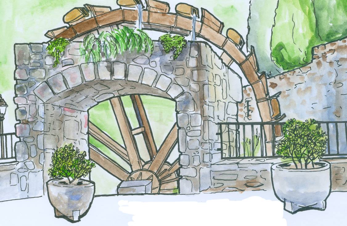
Next meeting of Urban Sketchers Girona

CAT

This Sunday, the next meeting of cartoonists in the village by the group Urban Sketchers Girona. You can’t miss this magical meeting of artists who will immortalize the spring beauty of our beloved Sant Llorenç de la Muga! #drawers


IN

This Sunday will take place the next meeting of Urban Sketchers Girona in our village. You can not miss this magical encounter of artists who will immortalize the spring beauty of our beloved Sant Llorenç de la Muga! #urbansketchers


IT IS

This Sunday, next meeting of cartoonists in the town by the Urban Sketchers Girona group. You cannot miss this magical meeting of artists who immortalize the spring beauty of our beloved Sant Llorenç de la Muga!

ROCK ROCK ROUTE - ROUTE TO ROCK ROCK MOUNTAIN

Here is the route to the rock of the rock, in our account of Wikiloc you will find more information about this route. in addition, you will be able to download the route on the gps and do it yourself or just follow the written and visual directions we provide on the page so you can enjoy the walk and arrive without any surprises. remember that at reception we have the printed version of the routes if you find it more practical.


CAT

The path to Roca de la Penya is a route of medium difficulty to the base of the rock, and more complicated if you want to climb to the top of the rock, as it requires climbing a few meters.

ESP
The road to Roca de la Peña is a route of medium difficulty to the base of the rock, and more complicated if you want to climb to the top of the rock, since it requires climbing a few meters.

ENG
The path to Roca de la Penya is a route of medium difficulty to the base of the rock, and more complicated if you want to climb to the top of the rock, as it requires climbing a few meters.

CAT
We start the route at the entrance of Camping La Fradera (Sant Llorenç de la Muga). Head to the right, passing by the footbridge next to the road, towards the village of Sant Llorenç. At the bend, pass the hermitage of Sant Antoni and cross to the other side of the bridge. Once you cross the bridge, take the path on the left that starts to climb the mountain. Continue straight on the paved road. At the first intersection, take the path on the right. Always continue straight on the path. At the next intersection of three paths take the one on the right to continue climbing the mountain. Continue straight, and at the next intersection turn right and continue uphill. Continue straight until the path ends. At the end of the path, you can choose to climb between the rocks and the reefs by a small path. Once in the mountain range you will see the Roca de la Penya on your left, it is the highest rock peak of all. You can get there by continuing between the rocks in this direction. Climbing to the top requires some technical skill / expertise or the help of a guide who knows it, as there are some drawings of the rock that make climbing easier. Extreme caution is required at the top as there is a downside.
ESP
We start the route at the entrance of Camping La Fradera (Sant Llorenç de la Muga). Head right, passing the footbridge next to the road, towards the town of Sant Llorenç. At the bend, pass in front of the Sant Antoni hermitage and cross to the other side of the bridge. Once you have crossed the bridge, take the path to the left that begins to climb the mountain. Go straight on the paved road. At the first intersection take the path on the right. Always continue straight on the road. At the next intersection of three roads, take the one on the right to continue climbing the mountain. Go straight on, and at the next intersection turn right and continue climbing. Go straight ahead until the road ends. At the end of the trail, you can choose to climb between the rocks and the reefs on a small path. Once in the mountain range of rocks you will see the Roca de la Peña on your left, the highest rock peak of all. You can get there by continuing between the rocks in that direction. Climbing to the top requires some technical skill / experience or the help of a guide who knows it, as there are some drawings of the rock that make it easier to climb. You have to be extremely careful at the top as there is a considerable setback.

ENG
We shall start the route at the entrance of the Camping La Fradera (Sant Llorenç de la Muga). Head right, passing the walkway next to the road, to the village of Sant Llorenç. At the curve, you should pass by the hermitage of Sant Antoni and cross the bridge. After crossing the bridge, take the path on the left which begins to climb up the mountain. Follow straight on along the asphalted road. At the first intersection take the path on the right. Continue straight on. At the next intersection of three paths take the one on the right to continue climbing the mountain. Continue straight ahead, and at the next intersection turn right and keep going up. Continue straight on until the end of the path. At the end of the path, you can still continue ascending through the rocks through a small path. Once in the rocky mountain range you will see Roca de la Penya on your left, it is the highest rock peak of all. You might get there walking along the rocks in this direction. Going up to the summit requires some technical / expertise skills or help from a guide who knows the place, because there are some shapes on the rock that allow you to climb more easily than others. Care must be taken at the top as there is a considerable downturn.

NEW Routes on Wikiloc | NEW trails in Wikiloc!

CAT

We have just uploaded two more routes to Wikiloc, suitable for both hiking and running or mountain biking! We continue to expand our list of routes in the area so that this summer you do not miss any of the hidden charms of our area. These are routes made by us, with our recommendations, photographs of the path and all the directions to get there. If you have any questions about the route do not hesitate to stop by the reception and we will solve all doubts so that you can adapt the path to the interests of your group.

LINK A WIKILOC


ENG

We have just uploaded two more routes to Wikiloc, suitable for hiking, running or do mountain bike! We continue to expand our list of routes on our surroundings so that this summer you won’t miss any of the hidden charms of our area. These are routes made by ourselve,, with our own recommendations, photographs of the paths and all the directions you need to get there. If you have any questions about the route, do not hesitate to come to the campsite reception to solve all your doubts, so that you might adapt the route to the bests interests of your group.

WIKILOC LINK


ESP

We have just uploaded two more routes on Wikiloc, suitable for both hiking and running or mountain biking! We continue to expand our list of routes in the area so that this summer you do not miss any of the hidden charms in our area. They are routes made by us, with our recommendations, own photographs of the road and all the directions to get there. If you have any questions about the routes, do not hesitate to go to reception and we will answer all your doubts so that you can adapt the route to the interests of your group.

LINK A WIKILOC

Go to Top